Visual Analytics for Multitemporal Aerial Image Georeferencing
Conference Paper
|
|
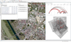
| Teaser Image | |
| Author | |
| Editor | |
| Abstract |
Georeferencing of multitemporal aerial imagery is a time-consuming and challenging task that typically requires a high degree of human intervention, and which appears in application domains of critical importance, like unexploded ordnance detection. In order to make a semi-automatic scenario possible, we introduce a Visual Analytics approach for multitemporal aerial image georeferencing designed in close collaboration with real-world analysts that face the problem on a daily basis, and implemented by combining computer vision and interactive visual exploration methods. We report on informal validation findings resulting from the integration of our solution into our users’ GIS platform of choice, which positively illustrate its effectiveness and time-saving potential.
|
| Year of Publication |
2017
|
| Conference Name |
8th International EuroVis Workshop on Visual Analytics (EuroVA)
|
| Publisher |
Eurographics
|
| Conference Location |
Barcelona, Spain
|
| ISBN Number |
978-3-03868-042-0
|
| DOI | |
| reposiTUm Handle | |
| Funding projects | |
| Paper | |
| Download citation |