DeVisOR - Detection and Visualization of unexploded Ordnance Risks
The project DeVisOR is concerned with the analysis of historical aerial photos (images) with the overall goal of detecting unexploded bombs.
- Silvia Miksch
- Paolo Federico
- Albert Amor-Amorós
Bridge 1 Programme of the Austrian Research Promotion Agency (FFG), funded by the Ministry for Transport, Innovation and Technology (bmvit).
Grant number 850695.
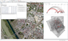
Analysis of historic air photos (images) with the goal of detecting unexploded bombs is a niche task, yet extremely important for preventing great damage or even loss of life. The computer science techniques and software tools currently available are of general nature, like Geographic Information Systems (GIS) and graphics editing programs. With these tools, the Luftbilddatenbank Dr. Carls GmbH, Vienna (LBDB), works on an even more complex task: the multi-temporal image analysis that takes into account historic prime records and other sources to gain information about air strikes, checking subsequent images for bombardment. The overall outcome is an Unexploded Ordnance (UXO) survey. In the project, interactive software tools will be developed that will support the work of the LBDB employees. These tools will incorporate new methods belonging to the fields of Computer Vision and Visual Analytics.
![]()
Publications
|
Albert Amor-Amorós, Paolo Federico, Silvia Miksch, Sebastian Zambanini, Simon Brenner, Robert Sablatnig, "Visual Analytics for Multitemporal Aerial Image Georeferencing", 8th International EuroVis Workshop on Visual Analytics (EuroVA), pp. 55–59, 2017. |
|
Paolo Federico, Albert Amor-Amorós, Silvia Miksch, "A Nested Workflow Model for Visual Analytics Design and Validation", Proceedings of the Sixth Workshop on Beyond Time and Errors: Novel Evaluation Methods for Visualisation (BELIV '16), 2016. Presentation on Vimeo |